Progress on an Arizona statewide groundwater assessment
About 40 percent of Arizona’s water supplies come from groundwater, making it a critical resource. However, measuring and monitoring this largely invisible water source is challenging.
Jay Famiglietti, a globally recognized groundwater expert and director of science for the Arizona Water Innovation Initiative (AWII), is working to address the gaps in our knowledge about Arizona’s groundwater. He and his team are making good progress on a statewide groundwater assessment that will help residents and decision-makers to better visualize the groundwater picture across the state.
Raised in Rhode Island, Famiglietti has subsequently spent his career in largely arid areas of western North America. He joined ASU in January 2023 after holding faculty and research positions at a range of institutions including the University of California, Irvine, the NASA Jet Propulsion Laboratory and the University of Saskatchewan.
Famiglietti has a deep interest and wealth of experience using technology including satellites and computer models to address water issues. He is now particularly focused on using satellite remote sensing technology to map how much groundwater Arizona has and how much we are using, as well as how much of it is accessible and of adequate quality to be used into the future.
“I think the groundwater knowledge gaps we have in Arizona are similar to those we have everywhere. We don't always know how much we have and how much of it is renewable,” Famiglietti says. “That makes it really hard to manage groundwater. Arizona is not unique. You could say a lot of the same things about California and many other places.”

Arizona’s 1980 Groundwater Management Act regulates groundwater in what are known as active management areas – largely in more urbanized areas of the state – as well as irrigation non-expansion areas. There is now interest from state and local leaders in finding ways to protect groundwater in more rural areas.
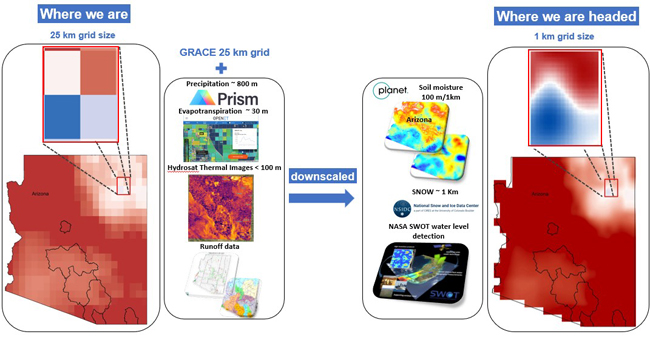
Famiglietti’s statewide groundwater assessment effort is utilizing data from a satellite mission known as GRACE – NASA's Gravity Recovery and Climate Experiment. He and his team are also taking advantage of technological advances that allow them to also integrate much higher resolution data into their assessment.
“We've got a pretty good 25 kilometer resolution view of groundwater across the entire state. That allows us to see how groundwater supplies are changing in every subbasin, every active management area and every irrigation non expansion area,” says Famigilietti, noting the vast improvement in data resolution. “In the old days we'd have been excited about 100,000 kilometer resolution!”
To get even higher resolution data, Famiglietti and others with AWII – a state supported program led by the Julie Ann Wrigley Global Futures Laboratory in collaboration with the Ira A. Fulton Schools of Engineering – are collaborating with private sector companies, specifically Planet and Hydrosat.
“These companies are doing things at very high resolution,” says Famiglietti. “Planet has provided us with one kilometer scale resolution soil moisture data for the entire state. Hydrosat just launched their first satellite to monitor surface temperatures at 20 meter resolution every day and we have access to that data.”

All of this data from GRACE, Planet and Hydrosat is being combined in a statewide land surface model based on what is known as NLDAS-3, or National Land Data Assimilation System - 3, in collaboration with researchers at ASU and the University of Arizona, as well as NASA Goddard. The combined data is then mathematically downscaled, which allows Famiglietti and his team to develop data products including images and maps at one kilometer resolution.
“That scale is important because it helps us see what's happening at the block or farm level,” says Famiglietti. “We will then know where water is being used, and if we need to work on doing things more efficiently, we can do that.”
Famiglietti says the team is about a third of the way to being able to provide a full picture of Arizona’s groundwater situation, aiming to have that completed in about a year. Along the way, he will be piloting the work in specific places. He’s also thinking in advance about a workflow that makes it relatively easy to update the data over time.

The work that Famiglietti is carrying out is complementary to other groundwater assessment work done by state agencies and other groups. For example, the Arizona Department of Water Resources is conducting a groundwater supply and demand assessment process.
Famiglietti is quick to point out the importance of these other studies, noting that the satellite-based work he is doing gives a “big picture” view across the entire state.
“That detailed picture is not possible using groundwater well data alone, though we certainly do need more of that,” says Famiglietti. “We simply don’t have the density of well measurements that we need to construct the larger picture.”
Famiglietti stresses that talking about groundwater protection is not about targeting any specific uses or places. In fact, he says, it’s the opposite.
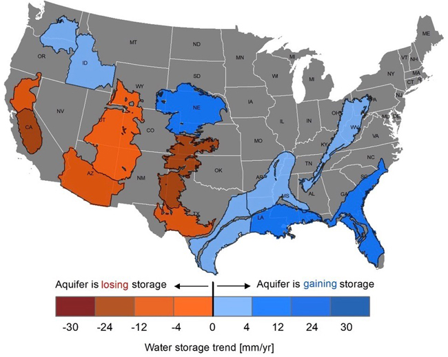
“What we are doing is characterizing what's there and how it's changing so that we can preserve it for multiple generations,” says Famiglietti. “What is happening around the world, and specifically in Arizona and across the southwest, is that groundwater is disappearing due to overuse. We are also looking at reductions in Colorado River water as the Basin aridifies, which will place even more pressure on groundwater.”
Famiglietti notes that the level of interest in groundwater from Arizona state agencies, from the Governor's office and from individuals and communities is remarkably high compared with places he has worked before.
“I hope that our work can empower communities to chart a path toward sustainable groundwater use,” says Famiglietti. “It’s particularly important in the southwest because that's the part of the country that's really drying out. A lot of the groundwater that we use today is not coming back.”
Famiglietti is heartened that Arizona is primed to take action to protect groundwater in rural areas of the state.
“Being able to provide useful information directly to communities and decision makers through AWII is remarkable. We have a huge opportunity with our very water forward state leadership and concerned communities to do something that truly protects groundwater and the many Arizonans that depend on it,” says Famiglietti. “We need to seize the moment.”
Related:
New partnership to quickly detect water supply and demand changes
Supporting rural communities to protect their groundwater
Matching groundwater withdrawal and recharge locations in the Valley of the Sun