Measuring how water and heat move in a desert city
Every day, we live with the growing severity of climate change impacts, triggered by human-induced warming. Urban environments are no exception. As cities expand, new challenges arise, such as traffic congestion, air quality exceedances, CO2 emissions and extreme heat waves.
Phoenix, Arizona, has urbanized at a rapid pace in recent years, increasing its population by over 11 percent between 2010 and 2020. This kind of urban development changes the way energy and water move through our environment, often leading to hotter and drier conditions.
Using advanced measurement and monitoring approaches, our research is aimed at better understanding how urban vegetation and other landcovers including lawns and parking lots influence heat and water levels in Phoenix. This information is valuable for communities and decision makers who wish to implement changes that can lead to a cooler, more sustainable city.
The energy balance in the city
You’ve probably noticed that cities often feel hotter than surrounding rural areas. That is because of the urban heat island effect. It happens when roads, buildings and other hard surfaces soak up the sun’s heat during the day and release it at night, keeping temperatures high.
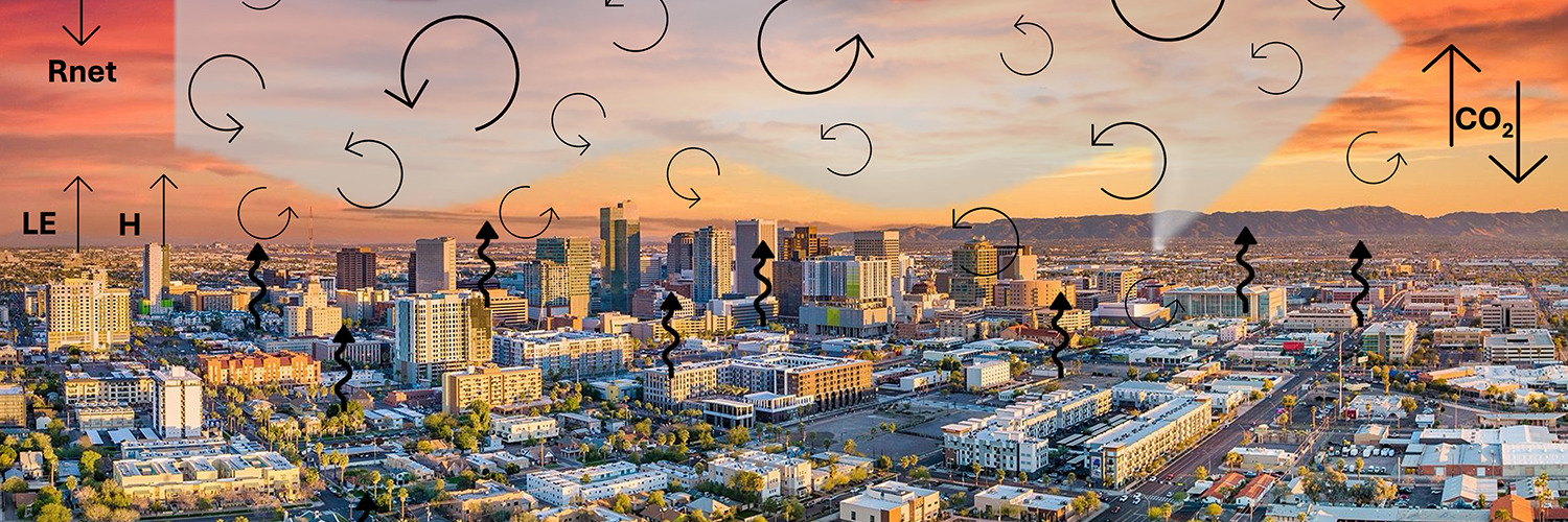
That heat depends directly on the energy balance, which is composed of net radiation and ground heat flux, balanced with sensible heat flux and latent heat flux. That last part — latent heat flux or evapotranspiration (ET) — is where water availability and plants come in.
ET is the combination of water evaporating from soil and surfaces and water released by plants as they “breathe.” Since plants help cool the environment through transpiration, more ET might lead to more evaporative cooling, but it also means more water use, which is a big deal in a dry place like Phoenix.
Evaporative cooling attributed to ET from urban vegetation is a significant and common strategy for reducing temperatures at the expense of consuming water. This can be especially important when summer heat waves pose a serious public health threat, which can be compounded by poor air quality arising from dust storms and other pollution sources.
By studying how much ET is happening in different parts of the city, researchers can better understand how urban plants and surfaces affect heat, especially during extreme summer temperatures. Likewise, measuring the energy balance components is important for protecting public health during heat waves and also supports better water use management, as ET is the largest water loss in arid regions.
How much of the evaporative cooling effect do we have in Phoenix?
We know that parks, trees and other green areas can help cool cities. But we still need to learn more about how different types of land including lawns, native vegetation and parking lots affect local temperatures and water loss through ET.
Despite many studies that have shown the efficiency of urban green spaces in mitigating urban heat island effects, there is a lack of understanding of how urban land covers can reduce air temperature through evaporative cooling.
Phoenix offers a great opportunity to study this. By setting up monitoring stations in different parts of the city, we can track how land use, drought, water use and extreme heat are all connected.
The challenges that Phoenix faces provide an opportunity to conduct continuous monitoring of urban land covers, including vegetated and non-vegetated areas with differing amounts of urbanization, to understand the variability of the ET and carbon dioxide fluxes. This monitoring can also shed light on the relationships between drought, outdoor water use and extreme heat waves.
Measuring evapotranspiration in different land covers
With the mindset of studying the interactions of these compounding threats, I am leading a network of monitoring sites in Phoenix to measure the water, energy and carbon balances as part of the Southwest Integrated Field Laboratory and the Arizona Water Innovation Initiative. This work is in collaboration with Professor Enrique Vivoni, director of the Center for Hydrologic Innovations, and a field research team at Arizona State University.
At each site we are monitoring the fluxes of water, carbon dioxide and energy fluxes between the surface and the atmosphere. A flux is defined as the amount of something passing through a known area per unit of time, in this case the amount of molecules of water and carbon dioxide contained in the air parcel passing through the instruments.
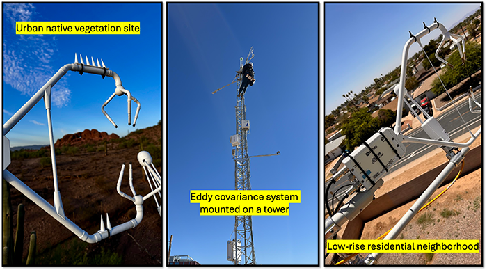
The instrumentation we use consists of a three dimensional sonic anemometer to measure the wind speed and wind direction at high frequency and an infrared gas analyzer to measure concentrations of water vapor and carbon dioxide. All are mounted on tall towers, along with other meteorological sensors to measure air temperature, relative humidity, soil moisture and radiation.
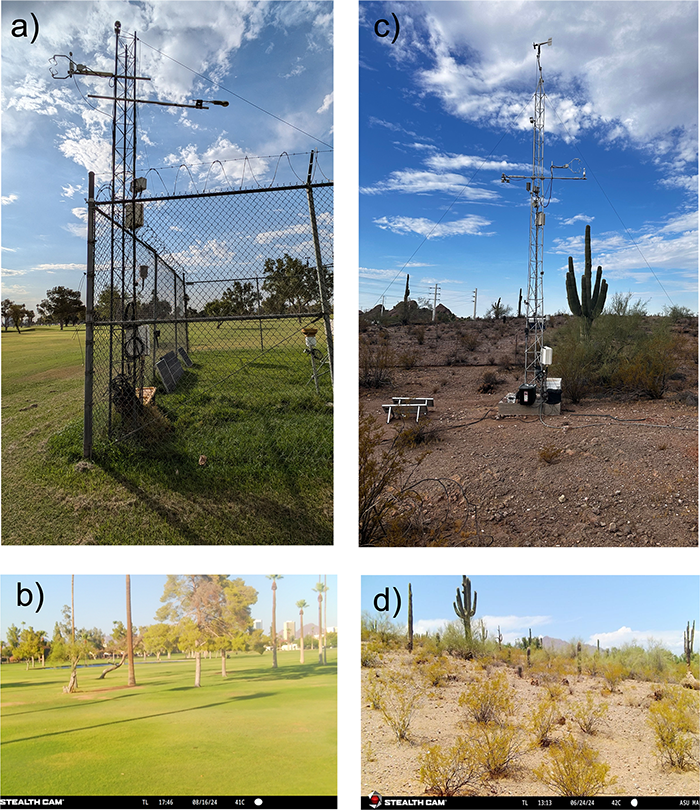
At present, five sites in different land cover types are part of this network: an irrigated golf course, a low-rise residential neighborhood, a well-preserved native vegetation site, a low-density urban development and a vehicle parking lot.
The various measurements at each site capture the exchanges for that type of urban land cover and expose how the fluxes are tied to human activities, such as irrigation, traffic and domestic practices.
What we are learning
We are finding that sites with more vegetation typically have more ET, which in turn cools the air in the area and lessens the impact of heat waves. More barren or built-up sites tend to amplify the effects of heat waves as they lack evaporative cooling.
However, there is more to be discovered, for instance how the cool air will transport and benefit surrounding neighborhoods, or how the presence of certain types of vegetation influence local temperatures and evapotranspiration rates.
Over the next few months, we will be strengthening this effort by expanding the network to more urban land cover types in order to have a more comprehensive perspective of the movement of water and energy in the urban environment. This unique urban network will be used to shed light on how urban spaces impact our surrounding environment and human health in Phoenix.
This research is helping city planners, water managers and policymakers make smarter decisions about how to design cities that are cooler, more sustainable and healthier for everyone, especially as climate change makes extreme heat more common.
By understanding how Phoenix’s urban landscape influences heat and water, we can take steps to make our city more livable for future generations.
About the author: Nidia E. Rojas-Robles is a Research Assistant Professor in the School of Sustainable Engineering and the Built Environment and the Center for Hydrologic Innovations at Arizona State University.
Related stories: